
A Severe Weather statement was released today at 11am for Whistler and the Sea to Sky, alerting us to a chilly weekend ahead:
via https://weather.gc.ca/warnings/report_e.html?bc39#1343138572095081950202212160502ws1171cwvr
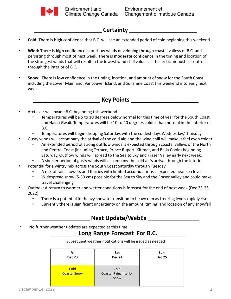
Wintry mix of precipitation followed by strong outflow winds, cold temperatures and wind chill this weekend.
Lil’wat Nation has shared the advice that “BC is expecting extremely cold temperatures this coming weekend. Please dress appropriately, travel with caution, and be aware of the symptoms of frostbite and hypothermia. A warming station will be open at Ts’zil to provide coffee, tea, and light snacks for any community members looking to escape the cold.
Hours:
Saturday, Dec 17 – 10:30 am to 5:00 pm
Sunday, Dec 18 – 9:00 am to 5:00 pm
Kúkwstum̓ckal̓ap | Thank you”
It doesn’t look as if we will see the coldest temps in the province, but the highways might get gnarly.
The outlook then shifts to more pineapple-like vibes, so cue your playlist to shuffle, as it seems we’ll be going rapidly from Let it Snow favourites to Caribbean groove station. We are nothing, by now, if not adaptable.

Where: Metro Vancouver, Fraser Valley, Howe Sound, Whistler, and Sea to Sky – Squamish to Whistler.
Hazard: Prepare for potentially challenging travel conditions. Check water pipes during the cold period.
Remarks: A series of weather systems will bring periods of snow to the south coast this weekend.
On Saturday, precipitation will fall as light flurries or showers depending on temperature and elevation. In general, 2 up to 4 cm of snow can be expected across the region. For Metro Vancouver, snowfall accumulations are mainly expected over higher terrain.
Saturday night through Sunday, an arctic front from interior BC will move across the south coast and bring a period of heavy flurries to the region. Currently, there is still large uncertainty associated with the timing of this system. Recent model guidance indicates total snowfall amounts near 10 cm are likely for the Fraser Valley, Howe Sound, Whistler, and the Sea to Sky highway. Near 5 cm of snow are possible over Metro Vancouver.
With the passage of the arctic front on Sunday, strong outflow winds will bring in cold arctic air and temperatures falling 5 to 10 degrees below seasonal average.
Please stay tuned to the updated weather forecast and warnings this weekend, and be prepared for changing road conditions and cold temperatures.
Weather in the mountains can change suddenly resulting in hazardous driving conditions.
Road conditions are available at http://www.drivebc.ca.
Please continue to monitor alerts and forecasts issued by Environment Canada. To report severe weather, send an email to BCstorm@ec.gc.ca or tweet reports using #BCStorm.
